
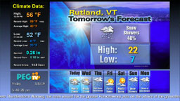
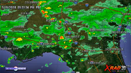
IntelliWeather makes use of state-of the art 3D terrain mapped imagery using Google Earth to provide a stunning yet low cost solution to giving your audience a “3D” view of the weather, complete with motion animations to allow “flying through” your coverage area. Weather information of all kinds can be superimposed on the 3D global model, allowing for unique perspectives on the weather.
Some examples of the kind of 3D imagery that can be created and displayed are:
Current weather conditions – temperature, winds, wind chill, heat index, humidity, etc.
- High and low and historical data
- Satellite images
- Radar images
- Projected hurricane tracks
Some samples:
Low-cost licenses for use in broadcast, web, and digital signage are available. Contact us for more information.